Oxford Green Belt Way guide

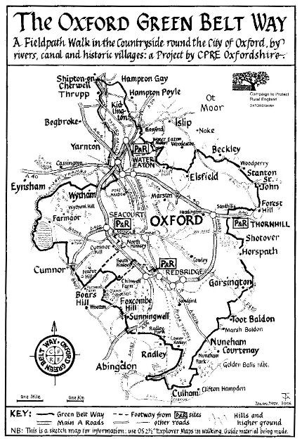
The Oxford Green Belt Way (OGBW) is a fifty mile circular walk exploring the countryside around Oxford, created by CPRE Oxfordshire in 2007. The whole route is waymarked with OGBW discs and is accessible by regular bus services, from four of Oxford’s Park and Ride sites, Oxford Parkway station and Radley station.
A full colour guide book is available, containing route maps for each stage of the walk, detailed route directions and lots of fascinating information. The rucksack-friendly paperback costs just £9.99 and is the perfect companion to help you find your way.
Copies are available direct from CPRE Oxfordshire and from selected bookshops, stationers and information centres in Oxfordshire and surrounding counties. It is also available on-line from Walking Pages. To obtain a copy from CPRE Oxfordshire, please send a cheque for £11.99 (which includes £2 postage & packaging) made payable to CPRE Oxfordshire.
Please remember to include the name and address of the person to whom the book should be mailed.
Oxford Green Belt Way
CPRE Oxfordshire
20 High Street
Watlington
Oxon
OX49 5PY
For further information email: administrator@cpreoxon.org.uk or telephone 01491 612079.
The route can also be downloaded here: Oxford Green Belt Way
However, please note this map is not maintained by CPRE Oxfordshire and there may be diversions in place which are not indicated.
Are you up for a challenge?
This year, we’ve launched the Oxford Green Belt Way Challenge, inviting budding walkers to complete the route within 12 months. Do you think you can rise to the challenge?
Find out More and Sign Up Here